- Published on 23 April 2024
The Greater Cairo region is central to urban and housing issues in Egypt. However, the last publicly available plan for it did not include much of the urban expansions made over the last decade, including the New Administrative Capital. Here, the Built Environment Observatory presents a recent mapping of this enigmatic region that has refused to be officially defined for decades, defining its area, analysing its population, and drawing its major transport networks.
All maps produced by the Built Environment Observatory are downloadable and reusable under the Creative Commons License 4.0 from this article in PNG format, and the BEO’s Archive in GIS formats.
Executive Summary
- Based on the contiguous urban agglomeration method, the Greater Cairo metropolitan area covered and area of 5,020 km2 at the end of 2023, ranking 35th in the word, and 2nd in Africa.
- The region comprises 22 administrative divisions with official boundaries, comprising three existing cities, 14 new urban communities (NUCs), and five peri-urban marakiz (counties).
- The NUCs cover 3600 km2, almost four times the original core urban area that existed up until 1977.
- As of July 2023, the Greater Cairo population stood at 18.8 million people, where only 1.5 million lived in the NUCs, representing less than 10% of the region’s population.
- Population density across the region was predictably varied, with higher densities in the old urban core and surrounding peri-urban areas, and very low densities in the desert NUCs.
- Khosoos and Shubra Al-Kheima in Qalubia to the far north of the region are the densest administrative divisions, with 77,663 and 39,404 inhabitants per square kilometre respectively. While the NUCs Shorouk and October Gardens have the lowest densities of approximately 400 people per square kilometre.
- Four further NUCs, including the New Administrative Capital, did not report any population in 2023, rendering almost one third of Greater Cairo uninhabited.
- Greater Cairo is the meeting point of nine regional highways and is at the centre of three ring roads.
- Despite its size, the Greater Cairo area is covered by only three metro lines, and one light rail transit line (LRT). A further metro line, and two monorails are currently under construction.
- The Greater Cairo Region had 8.6 million housing units as of the 2017 census, 43% of which were in the city of Cairo.
- Even though the NUCs covered the majoprity of Greater Cairo by area, they contained only 15% of the housing units, compared to 85% in the cities and marakiz.
- When compared with the number of households, Greater Cairo had an average vacancy rate of 44%, or 1.8 housing units per household.
- The NUCs had the highest vacancy rates of 85% in Badr (6.5 units per household), and 80% in 6th of October (4.9 units per household), averaging 72% across them (3.6 units per household), compared to 39% in exitsing cities and marakiz (1.6 units per household).
- Meanwhile, the lowest vacancy rates (28%, or 1.4 units per household), were reported in Markaz Osim, and the 15th of May NUC.
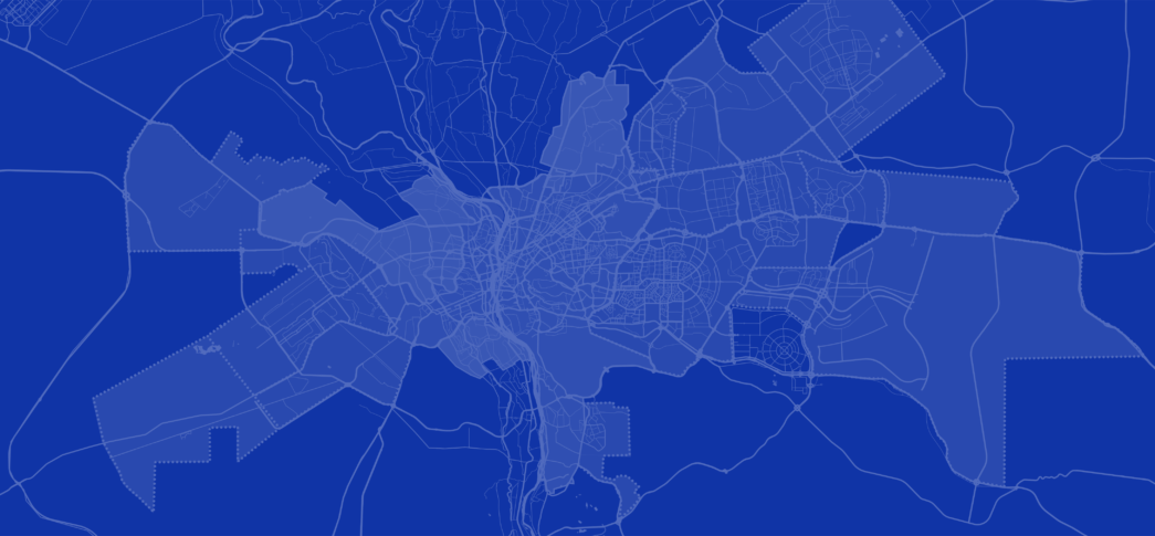
Figure 0: The Greater Cairo metropolitan area map in 2023
Introduction: Delineating the Metropolitan Area
While Greater Cairo exists in many plans, discussions and in the general mindset, it has no official administrative designation. While there is a Greater Cairo Region, it is a large ‘economic’ region that comspsrises the entire governorates of Cairo, Giza and Qalubia. Instead, over the last few decades urban planners have defined the metropolitan Greater Cairo depending on the projects they aimed to implement, commonly using the contiguous urban core of the cities of Cairo, Giza and Shubra Al-Kheima. Variations of the new desert settlements have been added to this core’s orbit, and at times, some of the adjacent peri-urban areas of once agricultural fields that have been urbanized. In this study, we aim to revisit the delineation of the Greater Cairo region based on the latest urban expansions that has seen metropolis grow far beyond its latest ‘borders’ marked some ten years ago. Further, we provide insight into the definition of metropolitan areas and the method to assess their boundaries, not as a prescription of what Greater Cairo should be, but what it can be.
The article starts with the major previous delineations mapped by local and international agencies for Greater Cairo from 1966 through 2014, providing a backdrop for how quickly the metropolis has changed. It then moves on to delineate the contiguous metropolitan region as it sprawls out today, in 2023, over a significant part of the Cairo, Giza, Qalyubia, and Sharkia governorates, made up of: the three contiguous cities of Cairo, Giza and Shubra Al-Kheima, new urban communities (NUCs or satellite cities) already built and operational as well as NUCs under construction, and marakiz (singl. markaz, or county)[1] on the peri-urban fringe. Here, Greater Cairo is represented through three main maps capturing its metropolitan area, demographics, and transportation network.
The main definition we have used to delineate Greater Cairo is based on how metropolitan regions are shaped when the urban centre expands significantly outside its borders. Greater cities are usually not defined as administrative divisions, where their definition differs from one major city to another. They rather comprise either a single city, such as Athens, Greece, or a clustering of two or more cities, for instance, Greater Porto, Portugal.[2] The metropolitan area is then a designation applied to reflect spatially contiguous sub-regions, composed of a densely urbanised core of at least 50,000 people with less dense nearby areas and towns that display a high level of social and economic influence. Greater London and Paris are clear examples of such an approach.[3]
Greater Cairo between 1966 – 2014
The Greater Cairo metropolitan area has seen several delineations over the last six decades, which have been modified and refined over the years while maintaining its principal concept of dense urban core and spatially adjacent units. The first master plan of Cairo was initiated by the Supreme Committee for Planning Greater Cairo in 1966,[4] which paved the way for the development of Nasr City and Helwan districts.[5]
1970: Greater Cairo Region Primary Master Plan, Supreme Committee for Planning Greater Cairo
The primary master plan of the Greater Cairo region completed in 1970,[6] marked the ring road as the peripheral boundary of the city’s urban agglomeration, and proposed NUCs beyond the dense core to accommodate the fast-growing population. The NUCs, which started to be developed following this plan, were: 10th of Ramadan (1977), 15th of May (1978), 6th of October (1979), and Obour (1982).
Figure 1: Supreme Committee for Planning Greater Cairo Primary Master Plan 1970
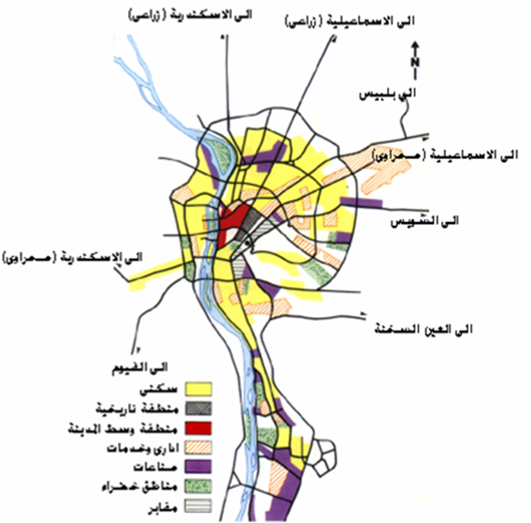
1982 – 1997: Greater Cairo Region Long Range Urban Development Scheme, GOPP-IAURF
The General Organisation for Physical Planning’s (GOPP) strategic plan in 1982[7] [8] designated the boundaries of Greater Cairo to include Cairo city and NUCs in Cairo governorate, all urban areas (cities and towns) in the Giza governorate in addition to its NUCs, as well as Shubra Al-Kheima city, the marakiz of Qalyub and Al Qanatir Al Khayriyyah as well as rural zones in Qalyubia governorate. The map focused on sprawl outside the settled core and combining smaller NUCs together to form larger satellite cities. In 1991, GOPP updated the plan addressing desert zones and new cities as new urban nuclei for the region including 10th of Ramadan, 15th of May, Obour, Badr, and 6th of October along with the ten NUCs surrounding the ring road which were combined to form New Cairo and Sheikh Zayed cities or extend 6th of October. Another revised plan in 1997 envisioned a second ring road for future urban expansion.
Figure 2: GOPP Greater Cairo strategic plan 1982
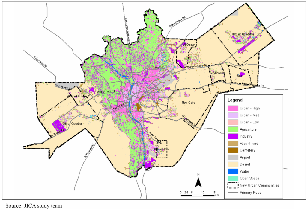
2008: Strategic Urban Development Master Plan Study for a Sustainable Development of the Greater Cairo Region, JICA
The Japan International Cooperation Agency (JICA) proposed plan in 2008 classified the Greater Cairo metropolis into three sectors: [9] the eastern sector contained 10th of Ramadan, Shorouk, and Badr cities, whereas Obour and New Cairo cities are added to the urban core, which combined the contiguous urban aggregation and rural zones in Cairo, Giza, and Qalyubia governorates. The western sector extended to Sheikh Zayed and 6th of October.
Figure 3: JICA Strategic Urban Development Master Plan for Greater Cairo 2027
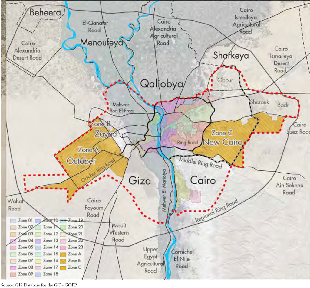
2012: Greater Cairo Urban Development Strategy, GOPP/UN-Habitat
The GOPP and the United Nations Human Settlement Programme (UN-Habitat) defined the borders of the Greater Cairo region in 2012[10] into the urban mass of Cairo governorate, part of Giza governorate, part of Qalubiya governorate, all then existing NUCs (namely the 6th of October, Sheikh Zayed, the 15th of May, New Cairo, Obour, Shorouk and Badr). The region was divided into 23 areas and three zones (A, B and C) covering the three NUCs (6th of October, Sheikh Zayed and New Cairo). The 10th of Ramadan NUC in Sharkia governorate, and all peri-urban or rural areas were not included. The metropolitan area extended over 3133 Km2, 48% of the region was in Cairo governorate, 47% was in Giza, and 5% was in Qalyubia governorate.
Figure 4: UN-Habitat Greater Cairo urban areas 2012
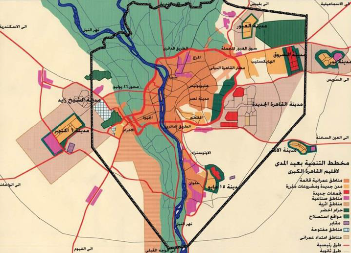
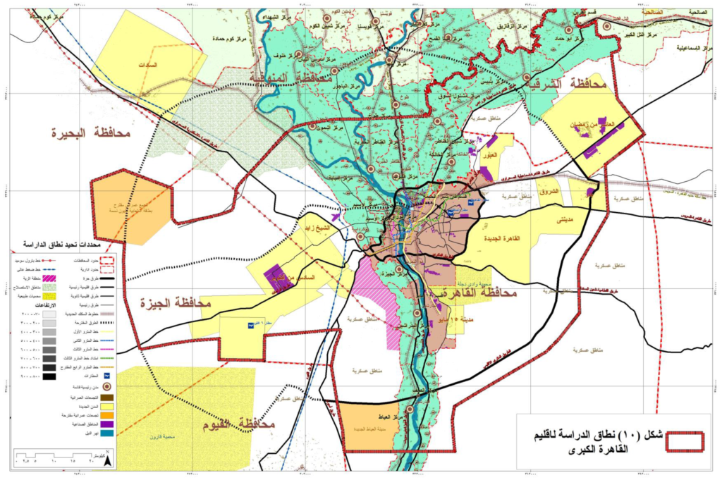
2014: Urban Restructuring of the Greater Cairo Region, GOPP
In 2014, GOPP proposed a plan to restructure Greater Cairo merging the urban mass with the peri-urban areas as one functional and urban zone,[11] while including NUCs already under construction or proposed at that time. The central core areas of the city exist as before, in addition to adjacent NUCs on the settled core’s eastern zone: New Cairo, Obour, Shorouk, New Heliopolis, Madinaty, Badr, Huckstep, in Cairo governorate, the Orabi Agricultural Cooperative in Qalubia, and 10th of Ramadan in Sharkia governorate. Whereas its western zone comprises the NUCs of Sheikh Zayed, 6th of October and a proposed NUC (unnamed). While the southern zone includes the 15th of May NUC and as well as Desert Hinterland Villages and a proposed NUC of New Ayyat (never realised). Moreover, the plan added a ‘rural zone’ comprised of bordering peri-urban areas, including eight marakiz in Sharkia, Qalyubia, and Monufia, and all the marakiz of Giza.
Figure 5: GOPP Greater Cairo study area 2014
Greater Cairo in 2023
After reviewing the earlier delineations and consecutive expansions of Greater Cairo, we produced three maps to update the present metropolitan area, assessing its population and presenting its expanded transportation network.
Greater Cairo Metropolitan region 2023
Based on the contiguous urban agglomeration method, Greater Cairo today sprawls over 5,020 km2, ranking 35th in the word,[12] and 2nd in Africa.[13] The region comprises 22 administrative divisions with official boundaries (See Appendix I). Three of which are cities that constitute the old urban core making up 16% of the area (Cairo, Giza, and Shubra Al-Kheima). In addition, there are now 14 NUCs that are built or still under construction making up the majority of Greater Cairo at 72% (New Cairo, New Administrative Capital, Shorouk, and Capital Gardens in Cairo governorate, 6th of October and its new extension, October Gardens, Sheikh Zayed and New Sphinx in Giza governorate, whereas Obour and New Obour cities in Qalyubia governorate, and 10th of Ramadan in Sharkia governorate). A further five adjacent peri-urban marakiz make up 13% of the area of Greater Cairo today (The marakiz of Markaz Kerdasa, Osim, and Abul Numros in Giza, and Al-Khankah and Khosoos in Qalubia).
Administratively, 47% of the metropolitan area is in Cairo governorate, 35% is in Giza, 9% is in Qalyubia, and 8% falls in Sharkia governorate. However, while all cities and marakiz are part of local government and should have elected local councils, all NUCs are under the jurisdiction of the New Urban Communities Authority (NUCA), affiliated to the Ministry of Housing, and thus have an exceptional administrative structure.
Accordingly, the new cities expand over 3600 km2, almost four times the existing core area. New Administrative Capital constitutes the largest area of the Greater Cairo region, followed by New Cairo city. Nonetheless, the region’s boundary combines peri-urban marakiz, which reflect spatial contiguity and a significant degree of urban expansion. Markaz Kerdasa, Osim, and Abul Numros are contiguous with Giza city and exposed to urban sprawl; areas are transitioning from rural to urban appearance. Markaz Kerdasa comprises major urban uses, such as Abu Rawash industrial area, the smart village, and Sphinx airport. Likewise, Markaz Al-Khankah and Khosoos city are spatially adjacent with Cairo; some units became partially or fully urban.
Figure 6: Delineation of the Greater Cairo Metropolitan Area 2023
Greater Cairo Demographics
The presented divisions -to designate Greater Cairo- introduce a total metropolitan population of 18.8 million, ranking the sixth largest metropolitan area by population.[14] Greater Cairo inhabitants are disaggregated into 54% in Cairo governorate, 31% in Giza, 13% in Qalyubia, and 1% in Sharkia governorate. 79% of the population inhabits the settled core; Cairo has the largest population of more than 9.5 million, followed by Giza, which has 4 million, while Badr has the lowest population size, 33 thousand. An aggregate of 1.5 million occupy the new cities, slightly higher than Shubra Al-Kheima city.
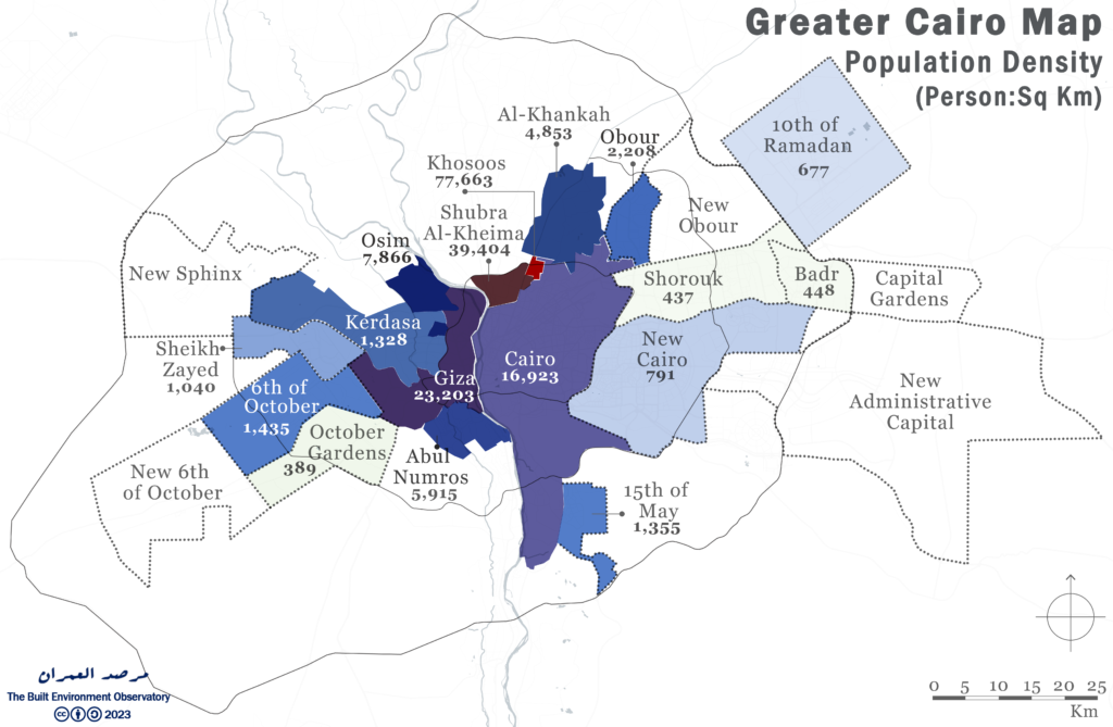
Figure 7: Greater Cairo population by city, markaz and NUC, 2023
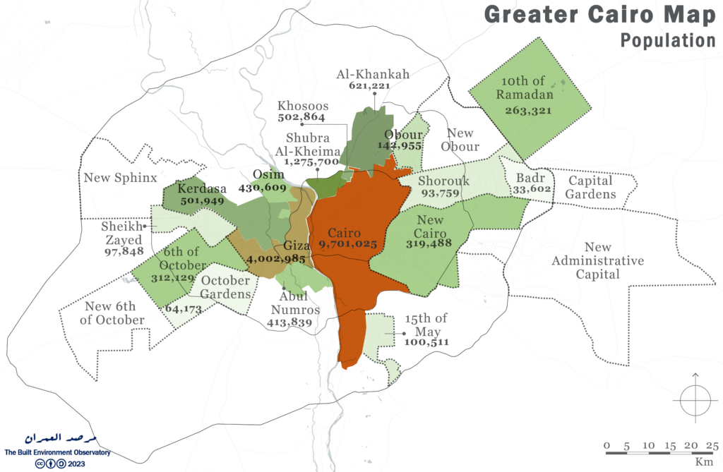
Correspondingly, a scale of variation distinguishes the population density of the metropolis sub-regions; Khosoos and Shubra Al-Kheima in Qalubia to the far north of the region are the densest administrative divisions, with 77,663 and 39,404 inhabitants per square kilometre respectively, whereas Badr, Shorouk, and October Gardens cities are defined by a small population density of approximate 400 persons per square Kilometre.
Figure 8: Greater Cairo population density by city, markaz and NUC, 2023
Greater Cairo Transportation Network
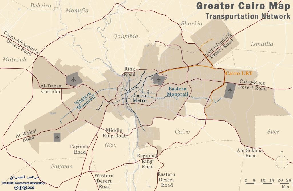
The metropolis is covered by a transportation network that reflects urban mobility patterns interconnecting the central mass with the outer zones. It constitutes a hierarchy of roads that range from highways to neighbourhood streets. Nine strategic corridors connect Greater Cairo with adjacent governorates: Alexandria, Matrouh, Al-Wahat, Fayoum, Ain Sokhna, Suez, Ismailia, Western and Eastern desert. Moreover, three ring roads pass through Greater Cairo sub-regions; the 100 Km ring road encircles most of the old urban core of the cities of Cairo, Giza, and Shubra Al-Kheima, while the 156 Km middle ring road crosses the new cities of Obour, Shorouk, 6th of October, and New Administrative Capital, and the 400 Km regional ring road connects major highways. Besides, public transportation particularly the urban rail transit system span the region’s area, highlighted by the rapid transit or Metro lines, the light rail transit (LRT), and two monorails. Cairo Metro comprises three lines, spreading over most of the settled core. Conversely, the two monorails connect the central mass with the eastern and western zones of Greater Cairo, and the LRT connects east Cairo to the New Administrative Capital.
Figure 9: The Greater Cairo transportation network in 2023
Greater Cairo Housing Units & Vacancy
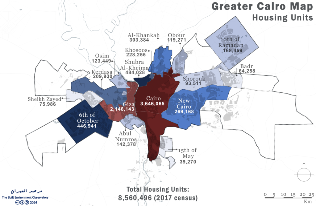
The Greater Cairo Region had 8.6 million housing units as of the 2017 census, 43% of which were in the city of Cairo (Fig. 10). Even though the NUCs covered the majoprity of Greater Cairo by area, they contained only 15% of the housing units, compared to 85% in the cities and marakiz. It is important to note that six NUCs, the Administrative Capital, Capital Gardens, New Obour, New October, October Gardens, and New Sphinx, were not created or administratively established at the time of the 2017 census, so no data has been reported for them.
Figure 10: Housing unit distribution in the Greater Cairo Region (See Appendix III)
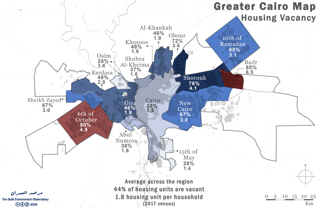
When housing units are compared with the number of households, Greater Cairo had an average vacancy rate of 44%, or 1.8 housing units per household. The NUCs had the highest vacancy rates of 85% in Badr (6.5 units per household), and 80% in 6th of October (4.9 units per household), averaging 72% across them (3.6 units per household), compared to 39% in exitsing cities and marakiz (1.6 units per household). Meanwhile, the lowest vacancy rates (28%, or 1.4 units per household), were reported in Markaz Osim, and the 15th of May NUC.
Figure 11: Housing vacancy rates in the Greater Cairo Region (See Appendix III)
Appendices
Appendix I: Total area, sub-areas, density and estimated population of the Greater Cairo region as of July 2023
| Governorate | Jurisdiction | City | Cordon Acres/ Feddan | Cordon Sq Km | Population | Density Person: Acre | Density
Person: Sq Km |
|
Cairo |
Local gov. | Cairo City |
141,655 |
573 | 9,701,025 | 68.5 | 16,923 |
| Cairo | NUCA | Badr | 18,545 | 75 | 33,602 | 1.8 | 448 |
| Cairo | NUCA | 15th of May | 18,329 | 74 | 100,511 | 5.5 | 1,355 |
| Cairo | NUCA | Capital Gardens | 33,800 | 137 | – | – | |
| Cairo | NUCA | New Administrative Capital | 223,383 | 904 | – | – | |
| Cairo | NUCA | New Cairo | 99,814 | 404 | 319,488 | 3.2 | 791 |
| Cairo | NUCA | Shorouk | 52,992 | 214 | 93,759 | 1.8 | 437 |
| Giza | Local gov. | Giza City | 42,630 | 173 | 4,002,985 | 93.9 | 23,203 |
| Giza | Local gov. | Markaz Osim | 13,527 | 55 | 430,609 | 31.8 | 7,866 |
| Giza | Local gov. | Markaz Kerdasa | 93,405 | 378 | 501,949 | 5.4 | 1,328 |
| Giza | Local gov. | Markaz Abul Numros | 17,289 | 70 | 413,839 | 23.9 | 5,915 |
| Giza | NUCA | 6th of October | 53,744 | 217 | 312,129 | 5.8 | 1,435 |
| Giza | NUCA | October Gardens | 40,749 | 165 | 64,173 | 1.6 | 389 |
| Giza | NUCA | New 6th of October | 78,198 | 316 | – | – | |
| Giza | NUCA | New Sphinx | 76,931 | 311 | – | – | |
| Giza | NUCA | Sheikh Zayed | 23,250 | 94 | 97,848 | 4.2 | 1,040 |
| Qalyubia | Local gov. | Shubra Al-Kheima City | 8,000 | 32 | 1,275,700 | 159.5 | 39,404 |
| Qalyubia | Local gov. | Khosoos City | 1,600 | 6 | 502,864 | 314.3 | 77,663 |
| Qalyubia | Local gov. | Markaz Al-Khankah | 31,629 | 128 | 621,221 | 19.6 | |
| Qalyubia | NUCA | Obour | 16,000 | 65 | 142,955 | 8.9 | 2,208 |
| Qalyubia | NUCA | New Obour | 58,914 | 238 | – | – | |
| Sharqiya | NUCA | 10th of Ramadan | 96,124 | 389 | 263,321 | 2.7 | 677 |
|
Total Cairo |
588,518 | 2,382 | 10,248,385 | 17.4 | 4,303 | ||
| Total Giza | 439,723 | 1,779 | 5,823,532 | 13.2 | 3,273 | ||
| Total Qalyubia | 116,143 | 470 | 2,542,740 | 21.9 | 5,410 | ||
| Total Sharkiya | 96,124 | 389 | 263,321 | 2.7 | 677 | ||
| Total Existing Cities | 349,735 | 1,415 | 17,450,192 | 49.9 | 12,329 | ||
| Total New Cities | 890,773 | 3,605 | 1,427,786 | 1.6 | 396 | ||
| TOTAL | 1,240,508 | 5,020 | 18,877,978 | 15.2 | 3,760 | ||
Sources: Central Agency for Public Mobilization and Statistics, “Estimated population”, July 2023
Appendix II: The sources of mapping the Greater Cairo metropolitan area according to cities cordon
All areas have been mapped by GIS from the below sources
| City | Sources |
| Cairo | Cairo Governorate Maps 2020, GOPP 2008* p.48 |
| Giza, Abul Numrous, Osim and Kerdasa |
Giza Governorate Maps 2016, GOPP 2008* p.48 |
| New Cairo | NUCA New Cairo page, PD 191/2000, 499/2016, MoH 1060/2017 |
| Shorouk | NUCA Shorouk page, MoH 227/2018 |
| Badr | NUCA Badr City page |
| Capital Gardens | NUCA Capital Gardens page, PD 645/2020 |
| New Administrative Capital | MoH New Administrative Capital Strategic Plan, PD 57/2016, Extension of New Administrative Capital, PD 333/2022 |
| 15 May | NUCA, 15 May page, PD 390/2017 |
| 6Th October | NUCA 6th October page |
| October Gardens | NUCA October Gardens page, Plan based on MoH 888/2019 |
| New 6th October | NUCA New 6th October page, MoH Master Plan, MoH 146/2018 |
| Sheikh Zayed | NUCA Sheikh Zayed page, MoH Strategic Plan, MoH 367/2020 |
| New Sphinx | NUCA New Sphinx Page, MoH 90/2020 |
| Shubra Al-Kheima | Qaloubia Governorate, Shubra Al-Kheima City 2023 |
| Khosoos | Khosoos City, PDP 2013 |
| Al-Khankah | Qaloubia Governorate, Al-Khankah Maps, CAPMAS 2016 |
| Obour | NUCA Obour City page |
| New Obour | Egypt’s Projects Map, New Obour City |
| 10th of Ramadan | NUCA 10th of Rmadan City page, Sharqia Governorate page |
| *GOPP, “Istratigeyet al-tanmaiya li-muhafzat al-gumhuriya: Iqlim al-qahira (Governorate Development Strategy: The Greater Cairo Region)”, General Organisation for Physical Planning (GOPP). 2008.
Notes: PD: Presidential Decree, MoH: Minister of Housing Decree
|
|
Appendix III: Housing units, households and vacancy rates by administritive division in Greater Cairo
| Governorate | Jurisdiction | City | Households (2017) | Housing Units (2017) | Units: Households Ratio | Housing Unit Vacancy |
| Cairo | Local gov. | Cairo City | 2,445,421 | 3,646,065 | 1.5 | 33% |
| Cairo | NUCA | Badr | 9,908 | 64,258 | 6.5 | 85% |
| Cairo | NUCA | 15th of May | 28,417 | 39,270 | 1.4 | 28% |
| Cairo | NUCA | Capital Gardens | NA census | |||
| Cairo | NUCA | New Administrative Capital | NA census | |||
| Cairo | NUCA | New Cairo | 89,360 | 269,168 | 3.0 | 67% |
| Cairo | NUCA | Shorouk | 22,871 | 93,511 | 4.1 | 76% |
| Giza | Local gov. | Giza City | 1,148,236 | 2,146,143 | 1.9 | 46% |
| Giza | Local gov. | Markaz Osim | 88,493 | 123,449 | 1.4 | 28% |
| Giza | Local gov. | Markaz Kerdasa | 107,509 | 209,930 | 2.0 | 49% |
| Giza | Local gov. | Markaz Abul Numros | 88,387 | 142,378 | 1.6 | 38% |
| Giza | NUCA | 6th of October | 91,466 | 446,941 | 4.9 | 80% |
| Giza | NUCA | Hadayek October | NA census | |||
| Giza | NUCA | New 6th of October | NA census | |||
| Giza | NUCA | New Sphinx | NA census | |||
| Giza | NUCA | Sheikh Zayed | 25,090 | 75,986 | 3.0 | 67% |
| Qalyubia | Local gov. | Shubra Al-Kheima City | 302,707 | 484,028 | 1.6 | 37% |
| Qalyubia | Local gov. | Khosoos City | 119,441 | 228,255 | 1.9 | 48% |
| Qalyubia | Local gov. | Markaz Al-Khankah | 162,311 | 303,384 | 1.9 | 46% |
| Qalyubia | NUCA | Obour | 33,236 | 119,271 | 3.6 | 72% |
| Qalyubia | NUCA | New Obour | NA census | |||
| Sharqiya | NUCA | 10th of Ramadan | 53,864 | 168,459 | 3.1 | 68% |
| Total Cairo | 2,595,977 | 4,112,272 | 1.6 | 37% | ||
| Total Giza | 1,549,181 | 3,144,827 | 2.0 | 51% | ||
| Total Qalyubia | 617,695 | 1,134,938 | 1.8 | 46% | ||
| Total Sharkiya | 53,864 | 168,459 | 3.1 | 68% | ||
| Total Existing Cities | 4,462,505 | 7,283,632 | 1.6 | 39% | ||
| Total New Cities | 354,212 | 1,276,864 | 3.6 | 72% | ||
| TOTAL | 4,816,717 | 8,560,496 | 1.8 | 44% | ||
| Sources: Central Agency for Public Mobilization and Statistics, “Population Census” and “Building Census“, 2017 (Cairo, Giza, Qalubia, Sharkia) | ||||||
Notes and Sources
[1] A markaz (lit. centre) follows a very hierarchical structure which almost always consists of a town (madina) considered the capital of the markaz and usually synonymous with the markaz’s name and designated as urban. The town is surrounded by main villages or village units (qura omm, or wehdat qarawiya), designated as rural and subsuming to the markaz capital. These in turn have satellite villages or hamlets (nuga’and ezab), subsuming to them. In rare cases, as some of the main villages grow, they are redesignated as towns.
[2] Eurostat, “Methodological Manual on City Statistics” (Luxembourg: Publications Office of the European Union, 2017).
[3] CFI Education Inc., “Metropolitan Statistical Area (MSA),” Corporate Finance Institute, accessed March 18, 2024.
[4] General Organistation for Physical Planning, “About GOPP,” accessed April 1, 2024.
[5] Japan International Cooperation Agency, “The Strategic Urban Development Master Plan Study for a Sustainable Development of the Greater Cairo Final Report (Volume 2),” 2008. p18.
[6] Japan International Cooperation Agency. p18.
[7] General Organisation for Physical Planning, “Development Strategy for Egypt Governorates: Cairo, Giza, Qalyubia,” 2008. p61.
[8] Japan International Cooperation Agency, “The Strategic Urban Development Master Plan Study for a Sustainable Development of the Greater Cairo Final Report (Volume 2).” p18-19.
[9] Japan International Cooperation Agency, “The Strategic Urban Development Master Plan Study for a Sustainable Development of the Greater Cairo Final Report (Volume 2).” p45.
[10] GOPP/UN-Habitat, “Greater Cairo Urban Development Strategy Part 1: Future Vision and Strategic Directions,” 2012. p32-33.
[11] General Organistation for Physical Planning, “Urban Restructuring Greater Cairo Region – Part I,” 2014. p55.
[12] Melly Alazraki, “The World’s Largest Cities by Area,” 24/7 Wall St., February 27, 2024.
[13] Global Geografia, “Largest Cities in Africa,” accessed April 2, 2024.
[14] Macrotrends LLC, “Largest Cities By Population in 2024,” accessed April 2, 2024.